Live Water Level Data
Red
= Flood Level
Green = Warning Level |
|
| Where it Floods: Measured at the
Guerneville Bridge |
32.0 Guerneville: Lower Mill Street;
Monte Rio: Old Bohemian Highway
32.5 Guerneville: Intersection
of Hwy. 116; Neeley Road; Mays Canyon Road
33.0 Guerneville:
Intersection of Drake Road and Hwy. 116, Pee Wee Golf, River Lumber Yard; Monte
Rio: Willow and Alder Streets, Forestville, Mirabel Trailer park
34.0
Guerneville: Riverside Park, Johnson's Resort, Creekside Resort, Neeley Road;
Northwood: Lower Northwood Drive
35.0 Guerneville: Parker's
resort on Neeley Road, Brookside Resort on Hwy. 116
36.0
Guerneville: Fern Grove, lower cabins
37.0 Guerneville: Mill
and 5th Streets; Monte Rio: River Boulevard at Heller
38.0
Duncans Mills: Portions of Freezeout Road
39.0 Hacienda:
River road begins to close; Rio Nido: canyon 7 Road at miniature golf course;
Guerneville: Triple R Resort
39.5 Hacienda: water to basements
of homes on River Road; Guerneville: Guerneville school yard; Monte Rio: Hwy 116
at D Street
40.0 Guerneville: dada river Hardware; Northwood:
Upper Redwood drive; Cazadero: Austin Creek road closes
40.5
Guerneville: Napa Auto Parts, Buck's Restaurant; River road closes to traffic
41.5 Guerneville: Stumptown Brewery at Midway Beach; Monte Rio:
Main intersection closes
42.0 Guerneville: Burdon's Restaurant;
Monte Rio: Old school begins to flood
43.0 Guerneville: Hwy.
116 at Surrey Inn closed to traffic
44.0 Guerneville: River
Lane at Vacation Beach
45.0 Flood Crest Jan. 1, 1997
45.0 Monte Rio: Bartlett's Store
46.0 Rio
Nido: River Road inundates; Guerneville: Main intersection begins to inundate
47.0 Guerneville: Businesses on north side of Main Street |
Water level information from the California Department of Water Resources
http://wwwdwr.water.ca.gov/
|
How to Read
The current water levels are on the far right. The information to left from there
traces conditions from the past 30 hours. The vertical line marks the change of
days at midnight. The levels are current within thirty minutes. Read the flood
forecast below or tune into the radio for accurate and up to date information. |
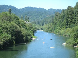
About Visiting
Most of the year the Russian River is gentle and filled with visitors and residents
swimming, canoeing and kayaking. It is the infrequent year that the river floods.
When the Russian River does flood, only certain areas are affected and conditions
quickly return to normal as the water recedes. People come to enjoy the beauty
of the area year round for wine tasting, hiking and sightseeing. |
|
