| Fort Ross was a thriving Russian-American Company
settlement from 1812 to 1841. This commercial company chartered by Russia's tsarist
government controlled all Russian exploration, trade and settlement in the North
Pacific, and established permanent settlements in Alaska and California. Fort
Ross was the southernmost settlement in the Russian colonization of the North
American continent, and was established as an agricultural base to supply Alaska.
It was the site of California's first windmills and shipbuilding, and Russian
scientists were among the first to record California’s cultural and natural
history. Fort Ross was a successfully functioning multi-cultural settlement for
some thirty years. Settlers included Russians, Native Alaskans and Californians,
and Creoles (individuals of mixed Russian and native ancestry.)
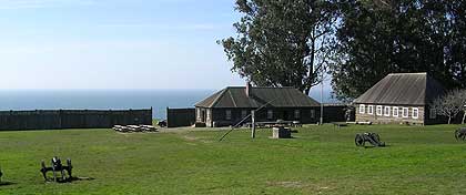
Along with the chapel, the structure of most historical interest at Fort Ross
is the Rotchev house, an existing building renovated about 1836 for Alexander
Rotchev, the last manager of Ross. It is the only surviving structure. Several
other buildings have been reconstructed: the first Russian Orthodox chapel south
of Alaska, the stockade, and four other buildings called the Kuskov House, The
Officials Barracks, and two corner blockhouses.
The park is 12 miles north of Jenner on Highway One. From Highway 101 there
are two routes to the fort:
From Petaluma
Highway 101. Take the East Washington Street exit. Go west (left). Washington
turns into Bodega Avenue, which after a few more name changes, turns into Highway
1 North and takes you to Bodega Bay. This route is a straight shot--much easier
to drive than it looks on the map. At Bodega Bay, follow Highway One North.
From Santa Rosa
Highway 101. Go past downtown exits for Santa Rosa. Just north of town, take the
River Road exit. Go west (left). River Road will turn into Highway 116 in Guerneville.
Follow 116 west, then follow signs to Highway One North towards Jenner and Fort
Ross.
From the North
Take Highway 1 from Fort Bragg and go south about two hours drive. We are about
16 miles from Stewart’s Point. Approximate driving times from... Santa Rosa
-- 1 1/2 hours San Francisco -- 3 1/2 hours Sacramento -- 3 1/2 hours Fort Bragg
-- 2 hours
Seasons/Climate/Recommended clothing
The weather on the coast is ever changing: you can expect fog, wind, sun or even
rain--sometimes on the same day. It is best to dress in layers. The ground is
often wet either from night moisture, fog, or rain, so appropriate shoes are advised.
Parking
The parking lot is just past the entrance station at the Visitors Center. All
vehicles must park in the parking lot. To aid those with limited mobility, cars
and busses can drive straight through the parking lot and take the dirt road to
the fort compound itself, unload passengers, and than drive back to the parking
lot to park. Cars can park near the fort compound with a visible handicapped sticker.
Buses may not park at the fort compound.
Picnicking and food availability
There is no food available at Fort Ross, so you should bring lunches and / or
snacks along with you. There are picnic tables near the parking lot, in the orchard
near the Call House, and in the fort compound itself. There are stores in Jenner,
and also north of the park about 2 miles for food and other supplies.
 Accessible
Features
Accessible
Features
Activities
 |
Exhibits & Programs |
 |
Fishing |
 |
Guided Tours |
 |
Hiking Trails |
 |
Primitive Camping |
 |
Scuba Diving |
Facilities
 |
Parking |
 |
Picnic Areas |
 |
Restrooms |
 |
Visitor Center |
Other
 |
Historical |
|